Showing posts with label [Selangor] Sungai Chiling Waterfalls. Show all posts
Showing posts with label [Selangor] Sungai Chiling Waterfalls. Show all posts
Sungai Chiling Waterfalls - Five River Crossings to The Majestic Falls (Part 4)
23 August 2009
9
comments

Article Preview

Title: This way to the Third River Crossing
Location: Sungai Chiling Waterfalls, Selangor, Malaysia
Date: 18th August 2009, 11:28am
Camera: Nikon D60 with Aperture: f/5.6, ISO Equiv.: 160
You have to walk for another 100 m to 300 m from one river crossing to another. This big piece of rock is a landmark guiding trekkers to the third crossing.

Title: Third River Crossing
Location: Sungai Chiling Waterfalls, Selangor, Malaysia
Date: 18th August 2009, 11:59am
Camera: Nikon D60 with Aperture: f/7.1, ISO Equiv.: 100
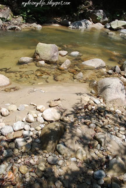
The third river crossing is waist deep (around my tummy area). Navigate your steps carefully. The river bottom is sandy and rocky.
Title: The Fourth River Crossing
Location: Sungai Chiling Waterfalls, Selangor, Malaysia
Date: 18th August 2009, 12:02pm
Camera: Nikon D60 with Aperture: f/7.1, ISO Equiv.: 100
The fourth crossing is pretty easy. But, never underestimate the depth of the river. Look at the blue mini signboard and also analyze the river for safe spots before making your move. Take your time to cross the river.
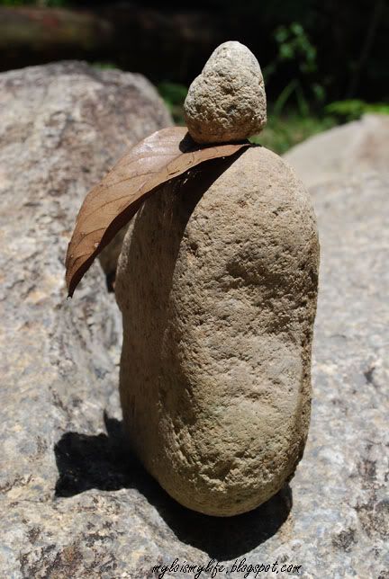
Title: The Luck of The Stoneman
Location: Sungai Chiling Waterfalls, Selangor, Malaysia
Date: 18th August 2009, 12:34pm
Camera: Nikon D60 with Aperture: f/8.0, ISO Equiv.: 100
Strange looking stones were placed next to the waterfall. Look like cairn. A cairn (carn in Irish, carnedd in Welsh, càrn in Scots Gaelic) is a manmade pile of stones, often in a conical form. They are usually found in uplands, on moorland, on mountaintops or near waterways. Source: http://en.wikipedia.org/wiki/Cairn
Many thanks to 1ondoncalling for his informative facts about these stones!
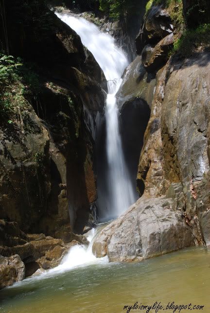
Title: FINALLY!!!!
Location: Sungai Chiling Waterfalls, Selangor, Malaysia
Date: 18th August 2009, 12:46pm
Camera: Nikon D60 with Aperture: f/32.0, ISO Equiv.: 100
I reached the lower fall after trekking for nearly one and a half hour. This is a powerful fall with a large natural pool. There are loads of 'kelah' fish at the pool (translation; mahseer fish), which like to nibble your feet. The other two waterfalls can be reach by climbing up the steep slope, just before the last river crossing. Check out my YouTube video below.
The second river crossing was pretty easy. The water was knee length. But, do not underestimate the river. The depth of the river varies from one spot to another. The sandy river bottom feels like quicksand - it gave way easily.
I was crossing the river with a knapsack and a big plastic bag of camera equipments. I look like a Mexican illegal immigrant trying to cross the U.S. border. But, that is the safest way to transport my gears (including tripod).
After crossing the river, I walked for another 150 m before reaching the third crossing. The third crossing can be dangerous. The water is waist deep (up to my tummy). Analyze the river before crossing. I look for safe spots along the river before making any move. The arrow from the mini blue signboards indicates the safest crossing.
The fourth and fifth river crossings are easy. Take your time to navigate your way safely across the river. The last river crossing (Number 6) is similar to third crossing - also waist level. At this point, you can hear thunderous sound of waterfall - an indication the falls are not far away.
After the sixth crossing, I trekked for another 200 m to the waterfall. At the falls, I removed my shoes and climbed up a gigantic rock (as big as a master bedroom). I set up my tripod and took some pictures of the waterfall. The height of this waterfall is roughly 14 m - 15 m. I spent one hour at the natural chilly pool beneath the waterfall before trekking back to the main entrance.
At first, I was confused and not very sure of the proper exit. Later, I decided to follow the flow of river. On my way out, I saw a fishery officer. He stared at me suspiciously. I guess he was upset.
He asked: 'You sudah register ke?' (Translation: Have you register?")
I answered: 'Belum' (Translation: No)
He added: 'Lain kali, you register baru masuk" (Translation: Next time, you need to register before entering the fish sanctuary)
I answered: 'OK' and paid RM0.50 as entrance fee.
I said to myself "Come onlah, you are not even here by 10:00am. Gates were locked!! How the heck am I going to register??"
To sum it up, I had a great time in Sungai Chiling Waterfall and Fish Sanctuary. It was an adventurous and exiting trip. I fell in LOVE with the lush greenery, the jungle trekking and the waterfall. This is an amazing place for nature lover and die-hard trekkers. Avoid making this trip during rainy season as the river will become impassable when the water level is too high. In the past, several fatal accidents have occurred during flash-flood.
Remaining pictures from Sungai Chiling Waterfalls & Fish Sanctuary
Sungai Chiling Waterfalls & Fish Sanctuary - Getting There:
Take the road from Kuala Kubu Baru to the Gap. After passing the Selangor Dam, you cross the bridge on the Chiling river. Just after this bridge you can park you car.
Sungai Chiling Waterfalls & Fish Sanctuary - Read More:
a) http://waterfallsofmalaysia.com/51chiling.php
b) http://mykeong.blogspot.com/2009/06/sg-chiling-waterfall-kubu-kota-bahru.html
Sungai Chiling Waterfalls & Fish Sanctuary - My YouTube video:
This video was recorded with my hand phone camera
Sungai Chiling Waterfalls & Fish Sanctuary - Google Maps:
Sungai Chiling Waterfalls - Journey Starts With An Adventurous Jungle Trekking (Part 3)
20 August 2009
2
comments

Article Preview
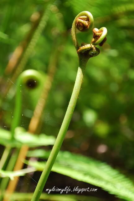
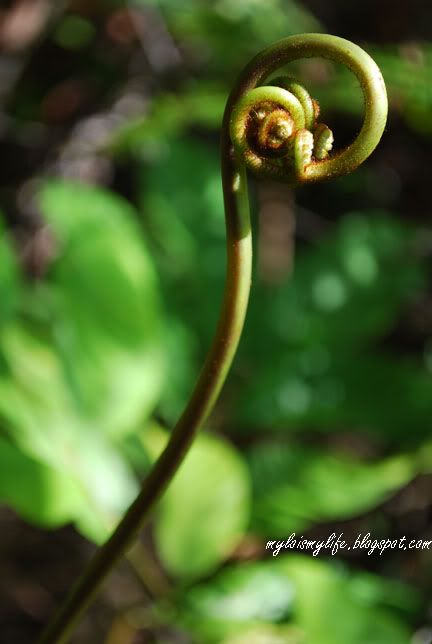
Title: Alien Life Form in District 9?
Location: Sungai Chiling Waterfalls, Selangor, Malaysia
Date: 18th August 2009, 2:40pm
Camera: Nikon D60 with Aperture: f/5.6, ISO Equiv.: 180
Nope. These are strange looking fern fronds that will develop into fern leaves. The frond in front has three circular loops while the frond at the back has a lollipop curve.
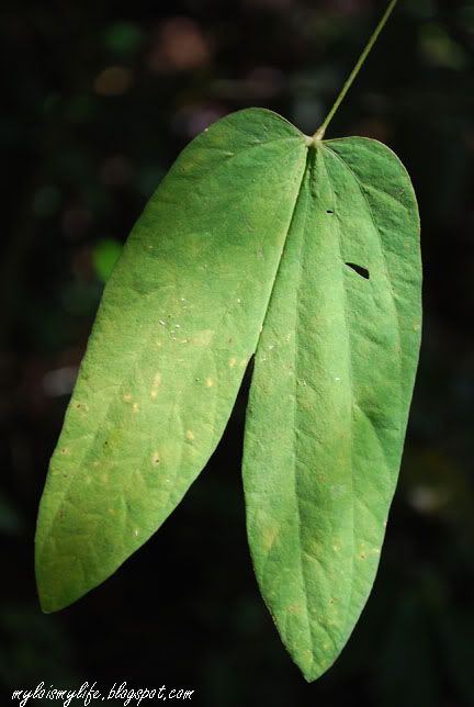
Title: Split
Location: Sungai Chiling Waterfalls, Selangor, Malaysia
Date: 18th August 2009, 2:45pm
Camera: Nikon D60 with Aperture: f/5.6, ISO Equiv.: 200
A unique looking leaf. Gee...it reminds me of something :)
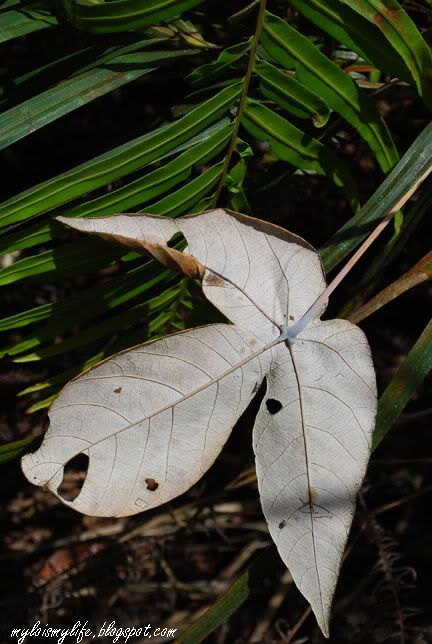
Title: Fallen
Location: Sungai Chiling Waterfalls, Selangor, Malaysia
Date: 18th August 2009, 2:25pm
Camera: Nikon D60 with Aperture: f/9.0, ISO Equiv.: 100
An irregular leaf fallen on a bed of fern leaves.
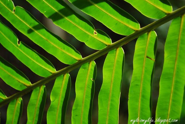
Title: Green!!
Location: Sungai Chiling Waterfalls, Selangor, Malaysia
Date: 18th August 2009, 11:08am
Camera: Nikon D60 with Aperture: f/5.6, ISO Equiv.: 180
A fern leaf illuminated by the sunlight. A close-up shot.
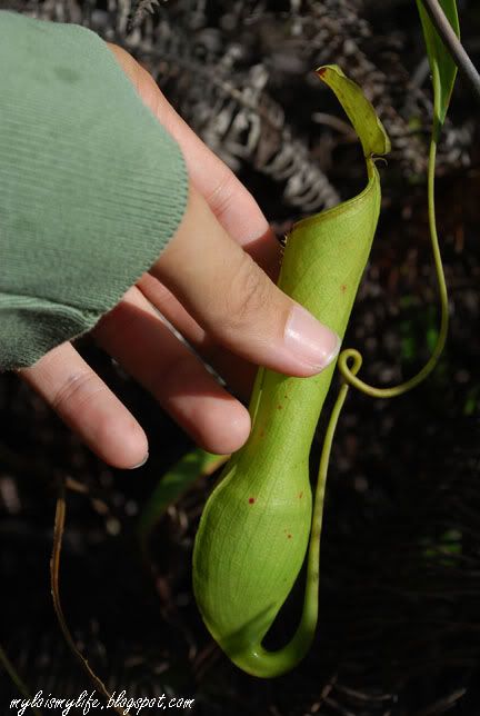
Title: The Green Pitcher
Location: Sungai Chiling Waterfalls, Selangor, Malaysia
Date: 18th August 2009, 10:33am
Camera: Nikon D60 with Aperture: f/8.0, ISO Equiv.: 100
Pitcher plants are carnivorous plants whose prey-trapping mechanism features a deep cavity filled with liquid known as a pitfall trap. I peek through these cups and discovered mostly drowned insects. Hold the pitcher gently to avoid yanking off the fragile extension at the bottom of the pitcher cup.
Title: The BIGGEST LOOPER
Location: Sungai Chiling Waterfalls, Selangor, Malaysia
Date: 18th August 2009, 2:24pm
Camera: Nikon D60 with Aperture: f/5.6, ISO Equiv.: 140
These loops will grow into fern leaves. Different species of fern has different looking loops. Some of them even look like an attacking centipede!
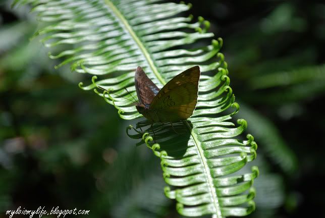
Title: Just Landed
Location: Sungai Chiling Waterfalls, Selangor, Malaysia
Date: 18th August 2009, 12:29pm
Camera: Nikon D60 with Aperture: f/7.1, ISO Equiv.: 100
A butterfly resting on a piece of fern leaf. A blooming fern leaf - the leaflets were growing outward.
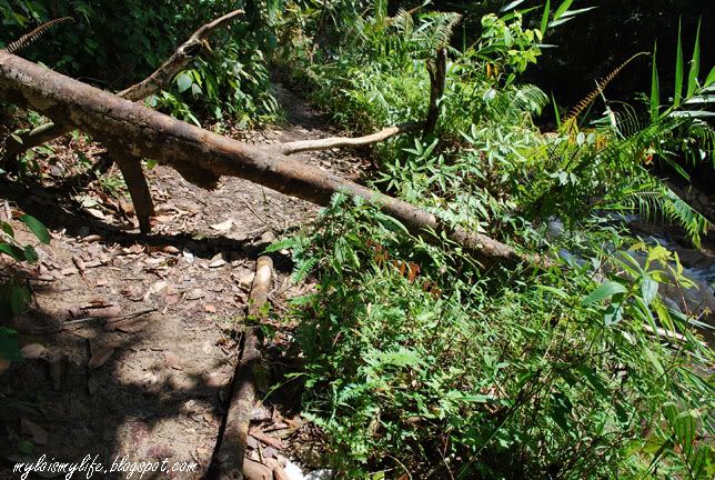
Title: The Jungle Trail and The River
Location: Sungai Chiling Waterfalls, Selangor, Malaysia
Date: 18th August 2009, 2:26pm
Camera: Nikon D60 with Aperture: f/6.3, ISO Equiv.: 100
Halfway trekking, you will encounter multiple pathways. If you are moving towards the waterfalls, remember to choose the trail closest to the river. Walk against the flow of river. NOTE: The jungle trail and the river is visible in this picture.
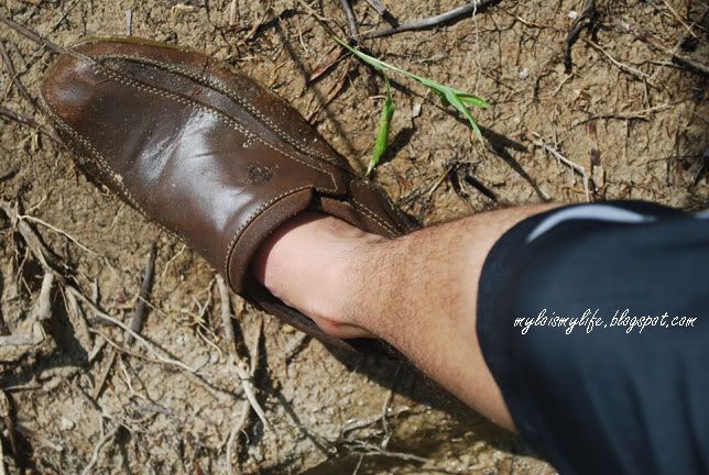
Title: Ready to GO!
Location: Sungai Chiling Waterfalls, Selangor, Malaysia
Date: 18th August 2009, 2:54pm
Camera: Nikon D60 with Aperture: f/6.2, ISO Equiv.: 100
After crossing several rivers, my shoes is all wet and soaked with water. I should have brought along a pair of slipper. Surprisingly, there are no leeches in Sungai Chiling. I guess the sandy and rocky surface is not a preferred habitat for the blood suckers.
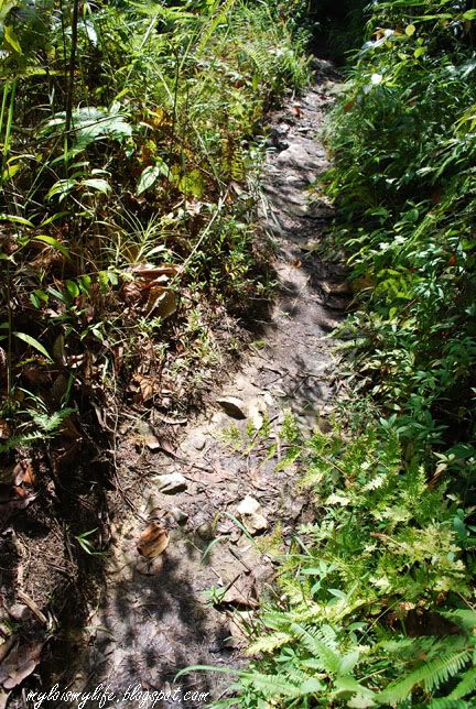
Title: The Jungle Trail
Location: Sungai Chiling Waterfalls, Selangor, Malaysia
Date: 18th August 2009, 10:53am
Camera: Nikon D60 with Aperture: f/6.3, ISO Equiv.: 100
Almost 90% of the jungle trail is wet and muddy.
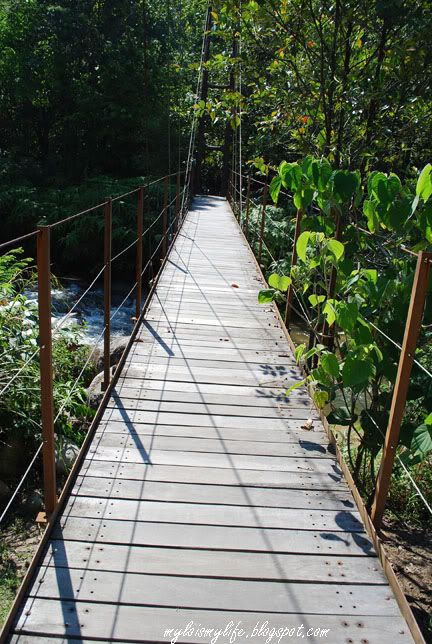
Title: The Suspension Bridge
Location: Sungai Chiling Waterfalls, Selangor, Malaysia
Date: 18th August 2009, 10:22am
Camera: Nikon D60 with Aperture: f/7.1, ISO Equiv.: 100
This is the first river crossing. The bridge is located next to the fishery office. Once you crossed the bridge, you will see a cross junction. Turn to your left, the path that look like a small stream is actually the trail.
This is my second trip to Sungai Chiling Waterfall & Fish Sanctuary. First trip was a failure - read my first post. My prime objective is to reach the waterfall in Sungai Chiling. On that day, my adrenaline was pumping. I was all gear up and very excited. I was speeding on the highway trying to reach Chiling's entrance as soon as possible.
I reached Sungai Chiling Waterfall & Fish Sanctuary by 10:00am. The jungle trail starts from the fishery office. So, I walked 400m to that entrance only to discover the wooden gates were locked. I decided to proceed anyway. I look left and right sheepishly, before climbing over the gates like a crook. It was pretty easy - a small rectangle gap to place my foot and leap over.
It was a great day for jungle trekking and river crossing - bright and sunny sky. To reach the waterfall, you need to trek for roughly 2km. After that, you have to cross five different rivers.
The first river crossing is the easiest. You just need to walk across the suspension bridge. Soon after the bridge, the jungle pathway is divided into three different trails. On my first attempt (Day 1), I lost my way trying to figure out the correct trail to the waterfall. It was confusing and frustrating!! I wasted 45 minutes trekking the wrong trails. The fishery department can do a better job by placing more informative signboards. Choose the left trail and walk all the way until you see a blue signboard that indicates the second crossing.
Trekking in Sungai Chiling is easy. But, 90% of the trail is narrow and overgrown with bushes of gigantic fern and thorny shrubs. The trail is sandy, rocky and 100% wet. Halfway trekking, you'll encounter multiple pathways. The safest way is to walk against the flow of river.
The lush greenery in Sungai Chiling is simply amazing. As usual, I was walking at a moderate pace searching for exotic floras and faunas. There were loads of pitcher plants, gigantic ferns and some wonderful creepy crawlies. After trekking for nearly one and a half hour, I finally reached the second river crossing.
More photos from jungle trekking in Sungai Chiling Waterfall (Slide show)
Coming Soon! Part 4 - The River Crossings & The Waterfalls. Detailed info about Sungai Chiling Waterfall & Fish Sanctuary (including road directions, maps and YouTube videos) are available in Part 4.