
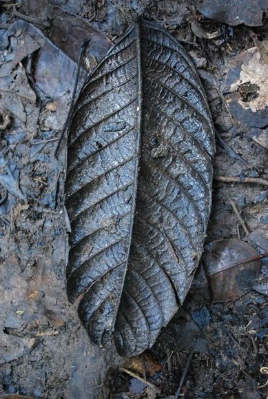
Article Preview
Title: Nature Nutrients 3
Location: The Pine Tree Trail at Fraser's Hill, Pahang, Malaysia
Date: 13 April 2009, 11:25am
Camera: Nikon D60 with Aperture: f/5.0, ISO Equiv.: 200
Another wilted leaf.
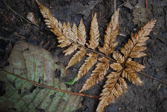
Title: Nature Nutrients 1
Location: The Pine Tree Trail at Fraser's Hill, Pahang, Malaysia
Date: 13 April 2009, 11:38am
Camera: Nikon D60 with Aperture: f/5.6, ISO Equiv.: 450
The forest floor is full of wilted leaves.
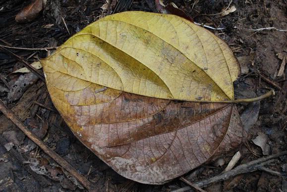
Title: Nature Nutrients 2
Location: The Pine Tree Trail at Fraser's Hill, Pahang, Malaysia
Date: 13 April 2009, 11:32am
Camera: Nikon D60 with Aperture: f/5.3, ISO Equiv.: 1600
An interesting leaf.
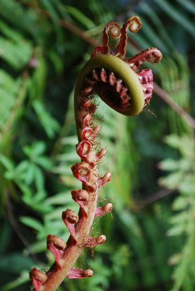
Title: GIANT CENTIPEDE! Nah....
Location: The Pine Tree Trail at Fraser's Hill, Pahang, Malaysia
Date: 13 April 2009, 10:38am
Camera: Nikon D60 with Aperture: f/5.6, ISO Equiv.: 200
A giant fern frond. The red blooming frond reminds me of a centipede posing to attack!
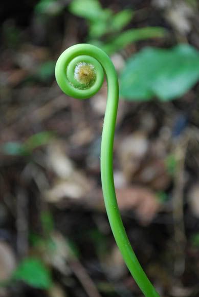
Title: The Green Loop
Location: The Pine Tree Trail at Fraser's Hill, Pahang, Malaysia
Date: 13 April 2009, 11:36am
Camera: Nikon D60 with Aperture: f/5.6, ISO Equiv.: 500
A young fern frond.
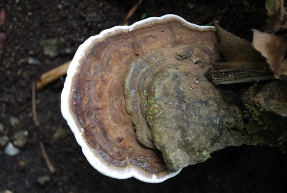
Title: Fungi
Location: The Pine Tree Trail at Fraser's Hill, Pahang, Malaysia
Date: 13 April 2009, 11:22am
Camera: Nikon D60 with Aperture: f/5.3, ISO Equiv.: 200
The jungle is full of fungi. This one pictured above is huge! Look like a large-sized pizza :)

Title: Wood Decay Fungi
Location: The Pine Tree Trail at Fraser's Hill, Pahang, Malaysia
Date: 13 April 2009, 12:35pm
Camera: Nikon D60 with Aperture: f/5.6, ISO Equiv.: 1000
This wood-decay fungus is a variety of fungus which has the ability to digest wood, causing it to rot.
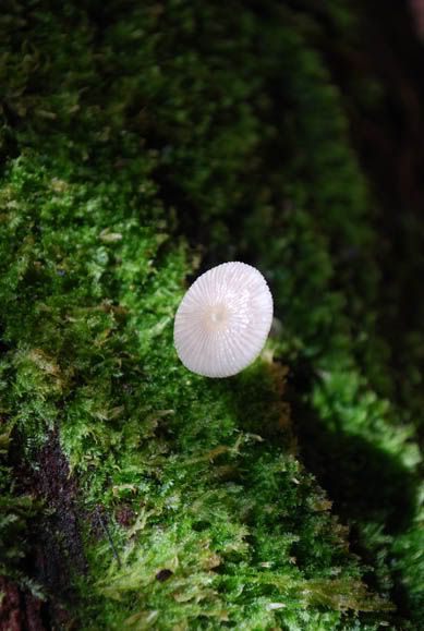
Title: White Umbrella
Location: Kuala Selangor Nature Park, Selangor, Malaysia
Date: 13 April 2009, 2:50pm
Camera: Nikon D60 with Aperture: f/5.6, ISO Equiv.: 200
A white fungi growing on a piece of dead log.
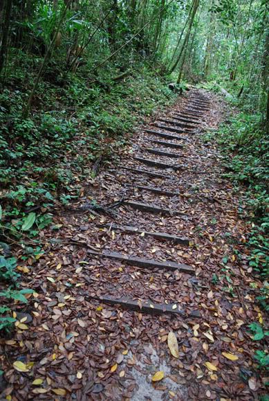
Title: Wooden Walkways
Location: The Pine Tree Trail at Fraser's Hill, Pahang, Malaysia
Date: 13 April 2009, 10:51am
Camera: Nikon D60 with Aperture: f/3.5, ISO Equiv.: 720
Wooden walkways that last for only less than 100m at the beginning of the trail.
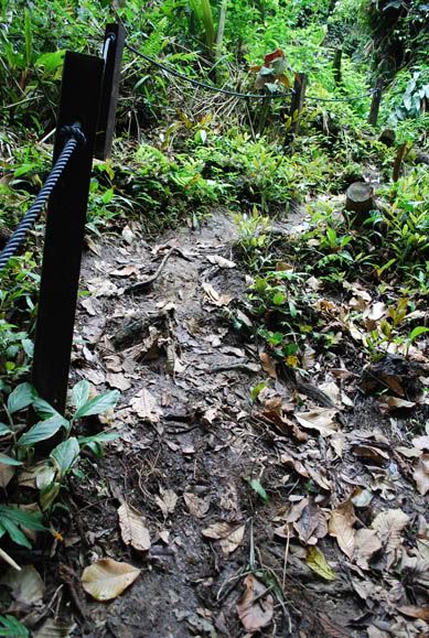
Title: Hang on to the ROPES!
Location: The Pine Tree Trail at Fraser's Hill, Pahang, Malaysia
Date: 13 April 2009, 11:20am
Camera: Nikon D60 with Aperture: f/4.5, ISO Equiv.: 200
Ropes, wooden walkways and concrete stairs are only available on certain stretch of the trail. After that, you are totally on your own.
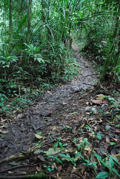
Title: Endless GREEN
Location: The Pine Tree Trail at Fraser's Hill, Pahang, Malaysia
Date: 13 April 2009, 11:32am
Camera: Nikon D60 with Aperture: f/3.5, ISO Equiv.: 720
A rather smooth and easy trekking at the beginning.
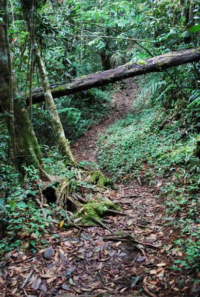
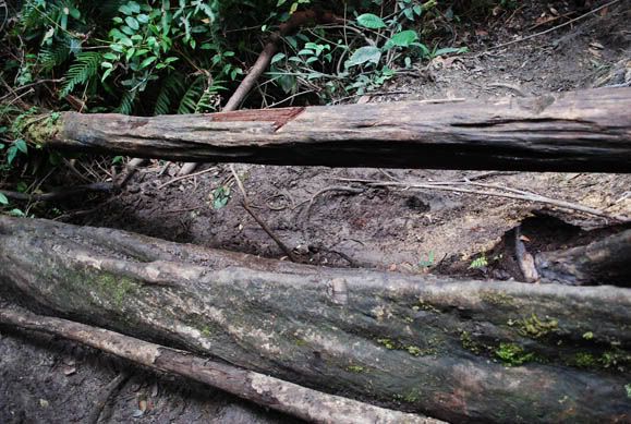
Title: A fallen tree
Location: The Pine Tree Trail at Fraser's Hill, Pahang, Malaysia
Date: 13 April 2009, 10:56am
Camera: Nikon D60 with Aperture: f/4.5, ISO Equiv.: 450
This is one of the easier obstacle during my trekking. I just need to bend my body a bit to walk through the trunk.
Title: The Slopes
Location: The Pine Tree Trail at Fraser's Hill, Pahang, Malaysia
Date: 13 April 2009, 12:04pm
Camera: Nikon D60 with Aperture: f/3.5, ISO Equiv.: 200
Descending a slippery slope. Some slopes are very steep and can be dangerous. I think I slipped and fall over 15 times during the entire trekking. No major harm. Only a minor bloody scratch on my fingers while I was grabbing a thorny stem for better grip and balance.
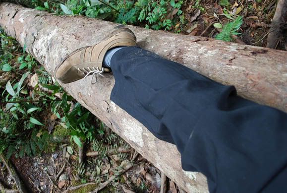
Title: Crawl and Leap Over
Location: The Pine Tree Trail at Fraser's Hill, Pahang, Malaysia
Date: 13 April 2009, 12:46pm
Camera: Nikon D60 with Aperture: f/3.5, ISO Equiv.: 280
There are lots of fallen trees along the way. I have to crawl and leap over these obstacles carefully. One small mistake and you'll end up rolling down the base of the forest.
Title: Time to take a REST
Location: The Pine Tree Trail at Fraser's Hill, Pahang, Malaysia
Date: 13 April 2009, 12:42pm
Camera: Nikon D60 with Aperture: f/4.0, ISO Equiv.: 200
Resting my feet on a huge fallen log.
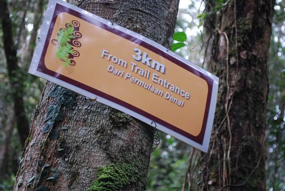
Title: HOW FAR IS THE PEAK?
Location: The Pine Tree Trail at Fraser's Hill, Pahang, Malaysia
Date: 13 April 2009, 12:44pm
Camera: Nikon D60 with Aperture: f/5.6, ISO Equiv.: 640
These signboard are very useful informing trekkers the distance they achieved from the entrance. I kept on looking at these boards to motivate myself to reach the 5500m mark!
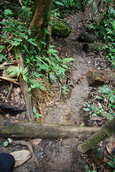
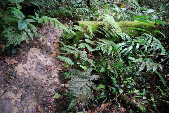
Title: The Forest Floor
Location: The Pine Tree Trail at Fraser's Hill, Pahang, Malaysia
Date: 13 April 2009, 10:52am
Camera: Nikon D60 with Aperture: f/3.5, ISO Equiv.: 200
A bed of wilted leaves covering the forest floor.
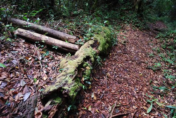
Title: The Pine Tree Trail
Location: The Pine Tree Trail at Fraser's Hill, Pahang, Malaysia
Date: 13 April 2009, 12:26pm
Camera: Nikon D60 with Aperture: f/3.5, ISO Equiv.: 560
Part of the trail was overgrown with trees and shrubs.

Title: A well-deserved REST!
Location: The Pine Tree Trail at Fraser's Hill, Pahang, Malaysia
Date: 13 April 2009, 2:16pm
Camera: Nikon D60 with Aperture: f/6.3, ISO Equiv.: 100
I slumped onto the ground the moment I reached the peak. I was tired, exhausted and dehydrated. This is the most challenging jungle trekking for me - by far :)
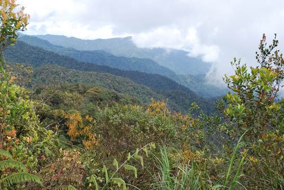
Title: THE PEAK! FINALLY!!!!
Location: The Pine Tree Trail at Fraser's Hill, Pahang, Malaysia
Date: 13 April 2009, 2.16m
Camera: Nikon D60 with Aperture: f/6.3, ISO Equiv.: 100
It took me 3 hours and 45 minutes to reach the peak of the Pine Tree Hill. Tiring yet full of JOY! I can see endless hills from here.
Recently, I did some research about interesting jungle trekking in Malaysia. I stumbled upon a place known as Fraser's Hill (Bukit Fraser) in Pahang. Rising 1,500 meters above sea-level on the Titiwangsa mountain range of Peninsular Malaysia is Fraser's Hill. There are 8 jungle trails over there:
a) The Bishop Trail (1500m)
b) The Rompin Trail (500m)
c) The Kindersly Trail (750m)
d) The Maxwell Trail (1800m)
e) The Hemmant Trail (1000m)
f) The Abu Suradi Trail (500m)
g) The Mager Trail (1000m)
h) The Pine Tree Trail (5000m/5km)
The most challenging trail is The Pine Tree Trail with over 5500m. I read some blog posting about people who conquered The Pine Tree Trail. Most of them concluded the trail is not for the faint of heart! The Pine Tree Trail is a challenging 5.5 kilometer trail up and down hills to the eponymous Pine Tree Hill, and you'll have to return the way you came. This is a full-day hike that will take 7-8 hours at a moderate pace.
I've explored the entire Bukit Nanas Forest Reserve and Kuala Selangor Nature Park. I believe I'm physically fit to conquer The Pine Tree Trail in Fraser Hill, Pahang. I did lots of readings and research to better understand the treacherous trail. I downloaded a comprehensive map listing all the eight jungle trails in Fraser's Hill. On Monday (13th April 2009), I decided to drive to Fraser's Hill referring to the Google Maps I downloaded earlier.

The comprehensive MAP with details about the location of trekking trails and places of interests in Fraser's Hill, Pahang. Click here to download the full map (large-sized):
It was a smooth two hours drive from Kuala Lumpur to Fraser's Hill, Pahang. I took the Rawang exit from the North-South highway and drive further north to Kuala Kubu Bahru and up to Fraser's Hill (over 100km). It was a snaky and winding road up to Fraser's Hill. You have to drive slowly and carefully when you are approaching Fraser's Hill because the lane get smaller on your way up. I nearly crashed into a car traveling downhill!
It was a quiet Monday on Fraser's Hill. I went to the Tourist Information Centre (TIC) located not faraway from the clock tower. I got myself a simlar printed map I downloaded earlier from internet. Time of arrival around 10.00am. I intend to book an economy room for an overnight stay after hiking the Pine Tree Trail.
Without wasting time, I refer to the map for the exact location of The Pine Tree Trail. I saw some other trails such as Abu Suradi Trail, The Mager Trail and The Hemmant Trail. I took at least 20 minutes to find the Pine Tree Trail which is located at the inner part of Fraser's Hill. I parked my car at an empty land next to some privately owned bungalows. I wore a long sleeve shirt to better protect myself from those mosquitoes and blood sucking insects in the forest.
I carry along my a camera bag with my NIKON D60 DSLR camera. In the beginning, it was a great pleasure trekking down the jungle. I can see some really mega-sized fern plants and lots of fungi here and there. The trails were clear with wooden planks embedded on the floor surface for better trekking. You can keep track of your trekking distance by referring to the label attached to the tree trunk.
I was a bit worried when I was halfway trekking The Pine Tree Trail. By the time I reached 2.5km from the starting point, I already taken one hour and 30 minutes! I quicken my pace to reach the summit of the hill. It was getting more challenging when I reached the 3km distance. No more wooden planks or ropes for better grip. The thick forest is overgrown blocking my way. I need to climb up and down the slippery slopes along the way. This UP AND DOWN trekking is really DANGEROUS! The trekking trail get even narrower from 4km onwards. One small mistakes, you'll end up rolling down to the base of the forest. I lost track on the number of times I slipped and fall. Fortunately, I managed to balance myself and grip to those huge trees along the way.
By the time I reached the 5km mark, I was totally tired and dehydrated. I made a big mistake by not bringing any water supply with me. Nonetheless, I soldiered on and move closer to the summit of The Pine Tree Trail. During the entire journey, I nearly given up hope finishing the trail. I kept on telling myself to give up and return back to the starting point. I have to keep my camera in the bag (most of the time) just to manoeuvre my way through these uneven trek. So, I missed out so many wonderful photo opportunity! The last 100m was really INSANE and IMPOSSIBLE! The last few distance of the trek is extremely steep. I took nearly 30 minutes trying to find the right footing to climb up this inclined slope. I can see the summit but I still have to climb up another 20 over steps.
I am already 5km away from the starting point. If I give up climbing up to the summit, I'm a real loser! So, I brave myself and calculate properly the right footing. I can see some leftover thick ropes attached to some huge tree trunks and huge rocks. Gosh, these ropes are broken into pieces of less than one metre long. I prayed hard that I won't fall down or worst case scenario - rope snapping into half. The final climb - an almost 75% incline. You will have to hold on to tree roots, rocks and the rope interchangeably to get up to the top. On my way up, I nearly fainted looking down. I kept on pushing myself.
FINALLY, I'm at the peak of The Pine Tree Hill! The view is simply SUPERB AND BREATHTAKING! The peak is even higher than some of those hills in the surrounding area. I captured some photos here and rest for 15 minutes. I completed hiking up 5 500m Pine Tree Trail for 3 hours and 45 minutes. I started my hike from 10.30am and reached the summit by 2:15pm.
I decided to hike down the hill as soon as possible. I know I needed another 3 - 4 hours to get back to the entrance. I have to return the same way I started earlier. There is no other exit available. It was a hell of an experience going back to the starting point. I was severely dehydrated and I got no more energy to move on. To make matter worse, it started to rain! Going back to the starting point is no easy task at all. I have to climb up and down the steep slopes again. My heart was beating VERY FAST and I was losing my breath! To be honest I felt like dying halfway back to the starting point. I was daydreaming about drinking chilled COCA-COLA and 100 plus. The tiredness is really out of the world. This is the first time in my life I felt so exhausted, worn-out and fatigued. I just slumped onto these huge tree trunk for every 10 steps ascending or descending the slopes. I needed to take at least 3 - 5 minutes rest before I can take another few steps. The last 2km back to the starting point is really killing me and break me into pieces. The rain was getting heavier, the sky is getting darker and the mist were all over the forest!
It was already 6.30pm or 4 hours since I was moving back to the starting point. I still have another 800m to go. My whole body was aching - my chest, my thigh and my legs. I fall down at least another 7 times on my way back due to the extra slippery floor from the rainwater. I moved slowly and managed to reached the starting point. It was 7.00pm in the evening. I'm thankful I made it back ALIVE. I took nearly 9 hours to complete 11km of foot trekking to and back of The Pine Tree Trail.
Later, I changed my clothes and drive to the nearest food stall and ordered two cans of soft drink: COCA-COLA and 100 PLUS. By 8pm, I decided not to stay overnight and drove back to Kepong. It rains heavily and it was pitch black on the road. Cold mist was blowing from all direction.
Looking back at this crazy trekking, I'm thankful I made it back alive and in one piece. This is the most challenging jungle trekking I had in my life. Overall, I enjoyed the whole experience. There is a bit of everything in this trail. Never monotonous The uneven trek is really trick, taxing and difficult. There are fallen trees along the way. You have to crawl and climb with extra care to avoid slipping down to the bottom of the forest. For those who are seeking for 8 - 9 hours of exciting and powerful trekking, you can pay a visit to The Pine Tree Trail jungle trekking in Fraser's Hill, Pahang. I have to agree with fellow trekkers that this place is definitely not for the faint of heart!
This is my timing:
Start journey: 7:10 a.m. from Kuala Lumpur
Arriving at the Gap or Guide House: 10:00 a.m.
Start trekking at: 10:30 a.m.
Ascent: 3 hours 45 minutes hours to the peak (reach the peak at 2:15pm)
Descent: Start time was 2:30 p.m. (reached back starting point at 6.50pm)
Total time spent: 8 hours 20 minutes
Here are some good pointers to remember:
a) Inform your family or friend at the hotel or the place you are staying in Fraser's Hill. You may also leave information t the local police station or Tourist Information Centre (TIC)
b) Inform them of your trekking plans and the time you are expected back.
c) Take along your mobile phone
d) Wear suitable clothes
e) Carry an adequate supply of drinking water (at least 2 - 3 litres), some food, a poncho, a guide map, a lighter and a torchlight with you
f) Time your trek because it gets dark in there faster than you think
g) Avoid trekking during rainy seasons. The forest floor get muddy and slippery.
The Pine Tree Trail, Fraser's Hill - Getting There:
Car
The journey takes approximately two hours from KL and is only accessible by road. Take the North-South Highway towards north, take the Rawang exit from the highway and drive further north to Kuala Kubu Bahru (KKB) and up to Fraser's Hill.
From KKB take the easterly road past the police station all the way along the winding roads to the Gap rest house. There is a one way up and one way down road system now at Fraser's Hill.
Bus
All public transportation to Fraser's Hill has been suspended since 1st January 2008. To get to Fraser's Hill, take the KTM Komuter from KL Sentral Station all the way to Kuala Kubu Bahru station and from there catch a taxi (not really a taxi but normally they are private owners who want to make a few Ringgit pocket money) all the way to Frasers. The fare is between RM50 - RM70 per way.
For the komuter KTM schedule, please go to: www.ktmb.com.my . From KL Sentral (timetable Seremban - Rawang route) take the komuter to Rawang and then change trains at Rawang station for Kuala Kubu Bahru (timetable = Rawang - KKB)
Taxi
From Kuala Lumpur to Fraser's Hill the estimated fare is from RM160 to RM180 per way per taxi.
7 Days Weather Forecast for Fraser's Hill:
Check the weather outlook in Fraser's Hill before you plan your trekking trip. Click this link to Malaysia Meteorologial Department:
More info:
Fraser's Hill Location (Google Maps):


I recently came accross your blog and have been reading along. I thought I would leave my first comment. I dont know what to say except that I have enjoyed reading. Nice blog. I will keep visiting this blog very often.
Ann
http://racingonlinegames.net
do you actually hike up all by yourself??
anyway, i seriously think that you should invest on some dunno what equipments (a total noob bimbo in camera-related things) for macro pictures of insects as it is a waste not to snap those aplenty little bugs in the jungle!!!
@AdeYing,Yep! It's a SOLO travel and discovery.
Hmmmm....not sure if I'm pretty good at capturing macro pics. It's not that easy to get a clear macro picture for the entire subject. Lots of ppl take macro pics of tiny little insects - the head part is crystal clear but the thorax and abdomen seems to be out of focus & BLUR! Have to learn from sifus first before investing my money on the macro lens :)
Cheers!
mylo
@ValoniaThank you!!!
Cheers!
mylo
Whoa, you did this all by yourself. Awesome madness...how was the last 100m climb in Pine Tree hills...
I want to know cause i'm mad on wanting to do this too. Pls drop me a mail at b_wars@yahoo.com if possible...pretty please.
@Anon,
Yep...looking back I think I was mad doing it all by myself. I guess it was on the spur of the moment to explore nature :)
The last 100m was VERY STEEP. Never look down when you are ascending the last few steps :)
OK..I'm sending an email to u.
Cheers!
mylo
im totally agree with u!
"this place is definitely not for the faint of heart!"
my friend and i has been there around november last year.
we started hike at 12pm and reached back starting point at 8pm.
This track is very challenging.
almost made me give up.
:: lyxa
Hi Ya,
It is so exciting to read your hiking experience. I'm truly inspired boy the fact that you did this trekking alone in your own style. I wish to try it once. May be I should wait for summer season to have better trekking experience.
BTW, Please mail me the trail maps.
May be you should try Gunung Ledang (Mt. Ophir). It could be bit more challenging (that's what I felt) than this one.
Hi there first of all i thank you for your nice blog and info about the pine tree trail, as I found it's very useful to plan my trip, as you mention the trail is tough, i just like to know if it's tougher than the Gunung Nuang peak trail? i might not check here frequently, would appreciate if you reply to kwpang.photography (at) gmail.com
thanks again.
keep blogging,eventho ive quit mine. in the blogspot only.hehe.
i'll go hike PTH this weekend,your blog is really inspiring.
Thanks God for blessing us with someone like you.