
Article Preview

Title: This way to the Third River Crossing
Location: Sungai Chiling Waterfalls, Selangor, Malaysia
Date: 18th August 2009, 11:28am
Camera: Nikon D60 with Aperture: f/5.6, ISO Equiv.: 160
You have to walk for another 100 m to 300 m from one river crossing to another. This big piece of rock is a landmark guiding trekkers to the third crossing.

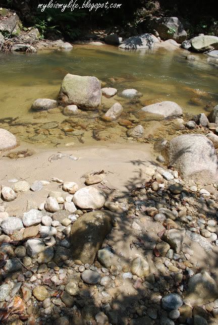
Title: Third River Crossing
Location: Sungai Chiling Waterfalls, Selangor, Malaysia
Date: 18th August 2009, 11:59am
Camera: Nikon D60 with Aperture: f/7.1, ISO Equiv.: 100
The third river crossing is waist deep (around my tummy area). Navigate your steps carefully. The river bottom is sandy and rocky.
Title: The Fourth River Crossing
Location: Sungai Chiling Waterfalls, Selangor, Malaysia
Date: 18th August 2009, 12:02pm
Camera: Nikon D60 with Aperture: f/7.1, ISO Equiv.: 100
The fourth crossing is pretty easy. But, never underestimate the depth of the river. Look at the blue mini signboard and also analyze the river for safe spots before making your move. Take your time to cross the river.
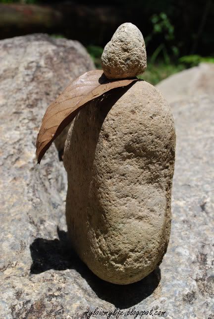
Title: The Luck of The Stoneman
Location: Sungai Chiling Waterfalls, Selangor, Malaysia
Date: 18th August 2009, 12:34pm
Camera: Nikon D60 with Aperture: f/8.0, ISO Equiv.: 100
Strange looking stones were placed next to the waterfall. Look like cairn. A cairn (carn in Irish, carnedd in Welsh, càrn in Scots Gaelic) is a manmade pile of stones, often in a conical form. They are usually found in uplands, on moorland, on mountaintops or near waterways. Source: http://en.wikipedia.org/wiki/Cairn
Many thanks to 1ondoncalling for his informative facts about these stones!
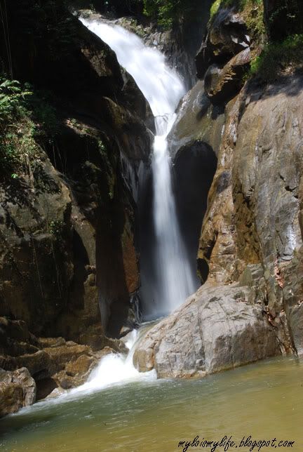
Title: FINALLY!!!!
Location: Sungai Chiling Waterfalls, Selangor, Malaysia
Date: 18th August 2009, 12:46pm
Camera: Nikon D60 with Aperture: f/32.0, ISO Equiv.: 100
I reached the lower fall after trekking for nearly one and a half hour. This is a powerful fall with a large natural pool. There are loads of 'kelah' fish at the pool (translation; mahseer fish), which like to nibble your feet. The other two waterfalls can be reach by climbing up the steep slope, just before the last river crossing. Check out my YouTube video below.
The second river crossing was pretty easy. The water was knee length. But, do not underestimate the river. The depth of the river varies from one spot to another. The sandy river bottom feels like quicksand - it gave way easily.
I was crossing the river with a knapsack and a big plastic bag of camera equipments. I look like a Mexican illegal immigrant trying to cross the U.S. border. But, that is the safest way to transport my gears (including tripod).
After crossing the river, I walked for another 150 m before reaching the third crossing. The third crossing can be dangerous. The water is waist deep (up to my tummy). Analyze the river before crossing. I look for safe spots along the river before making any move. The arrow from the mini blue signboards indicates the safest crossing.
The fourth and fifth river crossings are easy. Take your time to navigate your way safely across the river. The last river crossing (Number 6) is similar to third crossing - also waist level. At this point, you can hear thunderous sound of waterfall - an indication the falls are not far away.
After the sixth crossing, I trekked for another 200 m to the waterfall. At the falls, I removed my shoes and climbed up a gigantic rock (as big as a master bedroom). I set up my tripod and took some pictures of the waterfall. The height of this waterfall is roughly 14 m - 15 m. I spent one hour at the natural chilly pool beneath the waterfall before trekking back to the main entrance.
At first, I was confused and not very sure of the proper exit. Later, I decided to follow the flow of river. On my way out, I saw a fishery officer. He stared at me suspiciously. I guess he was upset.
He asked: 'You sudah register ke?' (Translation: Have you register?")
I answered: 'Belum' (Translation: No)
He added: 'Lain kali, you register baru masuk" (Translation: Next time, you need to register before entering the fish sanctuary)
I answered: 'OK' and paid RM0.50 as entrance fee.
I said to myself "Come onlah, you are not even here by 10:00am. Gates were locked!! How the heck am I going to register??"
To sum it up, I had a great time in Sungai Chiling Waterfall and Fish Sanctuary. It was an adventurous and exiting trip. I fell in LOVE with the lush greenery, the jungle trekking and the waterfall. This is an amazing place for nature lover and die-hard trekkers. Avoid making this trip during rainy season as the river will become impassable when the water level is too high. In the past, several fatal accidents have occurred during flash-flood.
Remaining pictures from Sungai Chiling Waterfalls & Fish Sanctuary
Sungai Chiling Waterfalls & Fish Sanctuary - Getting There:
Take the road from Kuala Kubu Baru to the Gap. After passing the Selangor Dam, you cross the bridge on the Chiling river. Just after this bridge you can park you car.
Sungai Chiling Waterfalls & Fish Sanctuary - Read More:
a) http://waterfallsofmalaysia.com/51chiling.php
b) http://mykeong.blogspot.com/2009/06/sg-chiling-waterfall-kubu-kota-bahru.html
Sungai Chiling Waterfalls & Fish Sanctuary - My YouTube video:
This video was recorded with my hand phone camera
Sungai Chiling Waterfalls & Fish Sanctuary - Google Maps:


An interesting area to trek. Flash floods at waterfalls are always unpredictable and dangerous. (Two Singapore trekkers were killed by such a flash flood in Pulau Tioman only two weeks ago. They made the fatal mistake of spending the night next to a waterfall.)
Hey MyLo,
I'm back! So envy of you that you're still actively visiting places. I had no time for anything at all besides my work which was really killing me.
Anyway, I'm taking 2 weeks off now and going to Laos soon. Hope to read more in your blog!
wow...great!! when are you going to take me exploring malaysia with you huuh?? i am now back home from china :) i found out that sungai chiling is pretty near my hometown leh
@Roger,
Yep, it's a NICE place for jungle trekking, river crossing & waterfall - 3 IN 1.
Never underestimate the waterfall!!! Avoid trekking to the fall during rainy season. The Chiling's management decided to prohibit camping next to the waterfall due to several fatal accidents in the past. Thank you for sharing this story. I found the link about the drowning incident.
2 drown in Tioman
http://tinyurl.com/n6omam
@Shelyn,
WOW!!! Laos! The temples over there are simply majestic!!!! Remember to visit Luang Prabang - the UNESCO World Heritage City.
Vietnam to the east, Cambodia to the south, Thailand to the west, Myanmar and China to the north - can explore more than one country.
Remember to bring back loads of pictures!!! I'm also traveling abroad again - from Southern Thailand en route to Bangkok.
BON VOYAGE & TRAVEL SAFE!!!
@fufu,
Three months in a blink of an eye. Finally, my buddy is back. I'll be checking out your great travelogue and precious pictures.
"when are you going to take me exploring malaysia with you huuh??" Soon, fufu :)
If you LOVE nature, jungle trekking & river crossing - Sg. Chiling is a MUST GO place!!
Cheers to all!!
mylo
mylo,
where is the fish sanctuary?where exactly are you planning to go in thailand, i had travelled extensively in thailand by land , maybe i can give you a few tips
Re: Curse of the Stoneman - piling up stones in such way is very popular in Scotland. I think it's called Cairn. People do it for fun, to make the submit, for luck, etc.
So it's not the curse. Maybe the Luck of the Stoneman!! ;-p
@xplorer,
The fish sanctuary is located exactly after the Selangor Dam. Take the road from Kuala Kubu Baru to the Gap. After passing the Selangor Dam, you cross the bridge on the Chiling river. Just after this bridge you can park your car. The entrance sign is on the right side of the road.
I'll be traveling to HatYai en route to Surat Thani and to Bangkok (Chatuchak Market, Grand Palace, Wat Pho, Wat Arun, Temple of Emerald Buddha, Yaowararat's Chinatown, Royal Barge Museum, Bangkok National Museum, Erawan Shrine, Lumpini Park, Dusit Palace, Jim Thompson House and more!!!
@1ondoncalling,
Thanks for sharing the info about 'cairn'! First time knowing such a thing about 'cairn'.
It seems they are built for several purposes including to mark a burial site or memorialize the dead. I found this wiki article:
http://en.wikipedia.org/wiki/Cairn
I changed the caption :)
Cheers!
mylo
i love chatucak market.Do visit the floating market at damnuern sabduak , a lot of photography opportunity.I normally stay at kritthai mansion hotel,a small clean and cheap hotel located in front of MBK and directly infront of national stadium lrt.it is also not far from jim thompson house.it is also a walking distance to siam paragon.check out the link http://kritthaimansion.com/
@xplorer,
I understand Chatuchak or Jatujak market is the largest open air market in the world. I am hoping to explore at least 50% of the market.
Thank you so much for sharing the info about floating market at damnuern sabduak. I definitely LOVE to explore this market.
I might be staying at Khao San area - cheap backpacker heaven :)
Cheers!
mylo